Cartography is the study and practice of making maps. Combining science, aesthetics, and technique, cartography builds on the premise that reality can be modeled in ways that communicate spatial information effectively. – Wikipedia
Maps, you know, those paper things that half of us can read and half of us cannot: they pointed the way to our destinations before the arrival of talking machines that tell us how to proceed – and then reroute. Maps that were, in theory, supposed to adhere to “the empiricist paradigm of cartography”—that cartography’s only ethic is to be accurate, precise, and complete. Of course that’s not what many maps are about – instead they often serve as a tool for persuading us to accept a particular view of the world, and not just geographically.

Why am I thinking of maps? I met two artists last week hard at work finishing their woodblock carving for the Exquisite Gorge project at Maryhill Museum, printing day on August 24th now rapidly approaching. Their art made ingenious use of a topological map of sections of the Columbia River Gorge in ways that tell an important story.
——————————————————————————————————————–
THE EXQUISITE GORGE PROJECT
“…a collaborative printmaking project featuring 11 artists working with communities along a 220-mile stretch of the Columbia River from the Willamette River confluence to the Snake River confluence to create a massive 66-foot steamrolled print. The unique project takes inspiration from the Surrealist art practice known as exquisite corpse. In the most well-known exquisite corpse drawing game, participants took turns creating sections of a body on a piece of paper folded to hide each successive contribution. When unfolded, the whole body is revealed. In the case of The Exquisite Gorge Project, the Columbia River will become the ‘body’ that unifies the collaboration between artists and communities, revealing a flowing 66-foot work that tells 10 conceptual stories of the Columbia River and its people.”
– Louise Palermo, Curator of Education at Maryhill Museum
——————————————————————————————————————–
Matthew Johnston, Associate Professor of Art History and Department Chair, and his colleague Tammy Jo Wilson,Visual Arts & Technology Program Manager at Lewis&Clark College, worked together with a group of students to tackle the challenge of representing Section 2 (River Mile 110 to McGowans Light, roughly from Troutdale to The Bridge of the Gods.) Unfortunately none of the students – most of them art and art history majors in their senior year – were able to make it on the day that I visited. Many of them have to work during the summer months – probably a drop in the bucket for the $64,186 annual cost (or thereabouts) of the 4 year-education at the school. How we burden these young people, our future.


Wilson earned a BA in photography from PNCA and a MFA in studio art from San Jose State University. Her artistic practice covers a wide variety of mediums, including encaustic painting, ink drawing, photography and textiles. She also co-founded a non-profit organization ArtinOregon, working to build bridges between artists and communities. If you hurry, you can explore her work for yourself – she is part of a thought-provoking two-person exhibit, Biological Dissonance, that is on view at the Chehalem Cultural Center until August 30th. Worth the trip to Newberg!


Johnston received his BA in printmaking from Yale University and his PhD in Art History from the University of Chicago. His focus is on modern visual culture, in particular nineteenth century popular media such as photography and print. He explores how certain kinds of print publications “used landscape images to motivate the expansion and development of the United States. In an era before film, such publications relied on inventive, sometimes pre-cinematic orchestrations of viewing and reading practices in order to make their ideological intentions more convincing and compelling.”
His book Narrating the Landscape: Print Culture and American Expansion in the Nineteenth Century describes how those who viewed landscape portraits accompanied by text narratives could be influenced to buy into certain ideas of “history, consumption and identity.” Said differently, citizens within a landscape undergoing massive cultural and economic change were subjected to manipulation of their perspectives. Travel guides, tourist literature, and federal expedition reports all played a role in this enterprise – as do, in general, maps, to get us back to where I started.

*
Cornell University has a wonderful introduction and collection of maps all sharing the purpose of persuasion. The topics range from religion, imperial geopolitics (think colonialism), slavery, British international politics, social and protest movements to, of course, war. The goal was made explicit in the 1920s (and later taken on in force by the Nazis) when in reaction to the shameful defeat in WW I German cartographers decided to go for the “Suggestive Map,” cartographic propaganda which they thought had given the British a strategic advantage.
“The goal of suggestive mapping was to achieve political objectives (while avoiding lies, which could be easily exposed) by appealing to emotions and rigorously excluding anything that didn’t support the desired message. Its maps were intended specifically to engage support from the general population, and they were often “shamelessly explicit. The movement produced “striking” results: by the early 1930s “there was a ‘virtual flood’ of suggestive maps in Germany; entire atlases were devoted to them, and they appeared in “every public lecture, every newspaper, and in countless books.”

Just like Johnston’s description of the landscape portraits, maps express particular viewpoints in support of specific interests. They can shape our view of the world and our place in it by selectively presenting information.
*
This modern insight led to the battle cry of The Map is NOT the Territory, which many readers might remember as the title of one of Portland Art Museum’s recent (terrific) exhibitions of regional artists giving their perspective on the place we live in.
The title was reportedly suggested by participating artist Mary Ann Peters, who had a gouache/ink drawing on black clayboard –slipstream (by the light of the moon– in the show. (I remember it vividly, it had a mesmerizing quality, inviting thoughts about watery surfaces. Peters’ projective plane seemed to contain the mirror images displayed in Rohrschach inkblot stimuli, but of course, on closer inspection, defied that expectation. Clever.)

The title was derived from Alfred Korzybski’s major publication: Science and Sanity: An Introduction to Non-Aristotelian Systems and General Semantics (1948.) He actually wrote, “The map is not the landscape, but if the map is similar to the structure of the landscape, it is useful“ which suggests a bit more than the general assumption that he referred only to the essential distinction between an object and its representation—or, more broadly, between our beliefs and the underlying reality. (You can read more about the exhibit, Korzybski and his link to Scientology as well as his thoroughly debunked General Semantics theory here.)
*
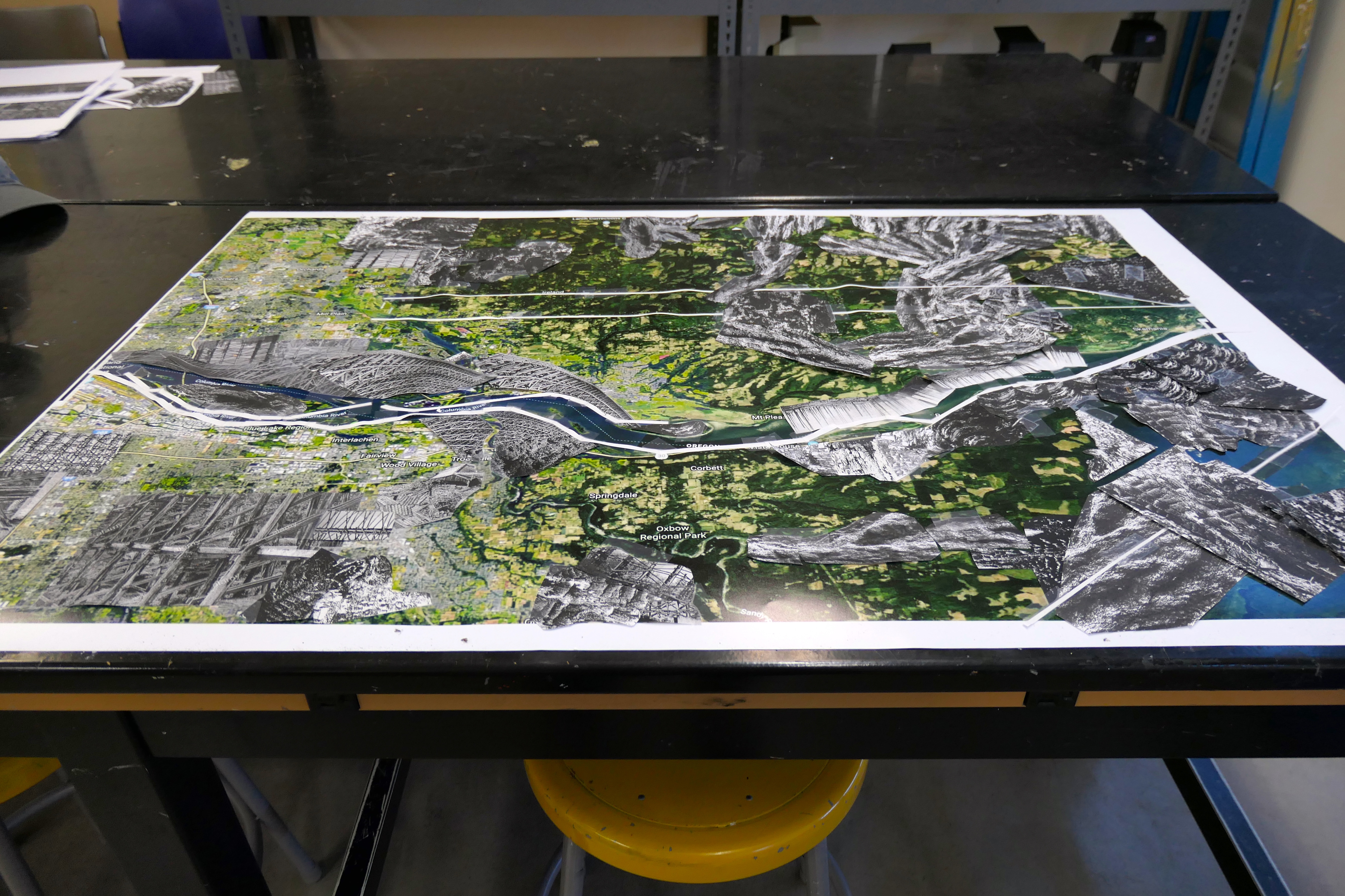
Johnston’s, Wilson’s and their students’ woodblock is carved with symbolic representations overlaid on a topographical map of The Gorge. It hones in on the 2017 Eagle Creek fire, delineating natural areas from those filled with man-made structures, depicted as burnt bark and steel train-trestles, respectively.


The wildfire, started by careless youngsters playing with fireworks, burned more than 48,000 acres in the Gorge and Mt. Hood National Forest. Hikers needed to be rescued, people lost homes and were evacuated. About 121 miles of national forest trails and the businesses of the area were affected during the three months duration of the fire and then some. Some trails, endangered by landslides, opened only years later. The artists’ “map” invites us to re-examine regional issues, and think through the history of the land. Cartographic suggestion, in other words, to contemplate the precariousness of the local ecosystem at the interface between urban areas and the wilderness.


Much research went into the planning of the design. The group hiked in the areas affected by the fire. They went to Corbett and interviewed people displaced by the fire and learned much about community building and neighborly help. This was particularly true for newcomers who buy property and build in areas previously unscathed by the expanding city lines and their support by those who were longtime residents and more familiar with protective practice against forest fires. People worked together to cut down brush too close to the houses, moved life stock and coordinated responses.


USGS geologist Steven Sobieszczyk was invited to give a lecture in the classroom and encouraged discussion with the student participants, which included Frankie Beilharz (responsible for a major part of the project, creating the photoshop documents for projection and transfer) and Shannon Drew, Anna Kahler, Iris Reidel, and Aiden Turlington. Photographs of burnt timber and bark formations were processed and used as models for the print design.


The visual appearance of the block is relatively abstract, regardless of its representational base. Just like fire destroys form, form in this depiction is reduced to patterned fields. I found this a clever echoing of the core of the narrative about wildfires. It is an invitation to rethink our usual categorizations. The perspectives of catastrophe, on the one hand, and renewal, on the other, are no longer quite delineated. Neither are the contours on the board. Just like “suggestive” maps can be tools of propaganda, they can be tools of contemplation, too, in this artistic form: a catalyst for reevaluating our approach to forest management and urban expansion.

*
Sarah Finger graduated from Whitman College in 2017 majoring in Geology. She also took many classes in the art department before her graduation, classes which exited her more than anything else. Like any true artist, she followed her calling and now has her own small print studio with a press and a drying rack (sacrificing half of her bedroom) and a day job at a brewery until she can earn a living with her art.


She was beyond thrilled when Nicole Pietrantoni called her this spring to rope her in for the Exquisite Gorge project, covering Section 10 (roughly Hat Rock to Snake River Confluence.) Pietrantoni, who received her MFA and MA in printmaking from the University of Iowa, is an Associate Professor in the Art Department with an artistic focus on the relationship between humans and nature. By all reports the students think she walks on water – I am eagerly anticipating meeting her at Print Day at Maryhill Museum. As someone with prior experience (she directed the Dia De Los Muertos Steamroller Print Project in Walla Walla, WA in previous years,) she will be hands on with the printing.

Finger told me that her former professor remembered her focus on geology and the two of them brainstormed about the design for the wood block. They talked about the dams and about the impact on tribal nations. It was only during a road trip along The Gorge on her way to pick up the board that she found herself pointing out to her boyfriend all the particulars in the geology of the region.
The ideas for the wood block were born: depict the cataclysmic force of the Missoula floods which periodically rushed across eastern Washington and down the Columbia River Gorge during the Pleistocene. Depict the giant granitic boulders carved by the water and the gravel bars that somehow ended up high on the bluffs, driven by the force of the flood. Unimaginably, the water burst through the base of the dam at a rate of ten times the combined flow of all the rivers in the world.

Depict unique rock formations, like Hat Rock near Umatilla, Oregon. The basaltic feature is the result of the Missoula Floods stripping away the outer surface of material, leaving behind the 70-foot-high monolith. Or the Twin Sisters, a distinctive basalt feature within the Wallula Gap, a part of the massive outpouring of Columbia River basalt lavas which were eroded by the Missoula floods. Add to that small text boxes (hard to carve, true devotion!) and you have miniature maps and tables like in a college textbook.


During our phone conversation – I did not have it in me to treck up to Bellingham, WA in this last week before the end of the project, I admit – Finger emphasized how much she enjoyed a project that provided the opportunity to combine her two passions, art and geology, each informing the other. She told of a fantasy that allowed her to time travel and observe the Missoula floods from the perspective of a bird. I, on the other hand, fantasize about being able to get into the brains of all these amazingly creative people I’ve met during these months of interviews and map how their neuronal networks are firing – maybe some of it will rub off….

*
I like maps, because they lie.
Because they give no access to the vicious truth.
Because great-heartedly, good-naturedly
they spread before me a world
not of this world.
This is the last stanza in the last poem written by Wisława Szymborska before she died, titled Map (the whole poem, translated from the Polish by Clare Cavanagh, can be found here.)
I would rephrase the sentiment, when thinking about the art I saw last week.
I like maps, because they offer an alternative. Because they give us access to a truth that’s our’s to create – to heal this planet and protect it. Because they spread a vision of a world that can be our children’s world.


Nicky
This is utterly amazing – words fail …
Sara Lee
This is a simply wonderful posting, in more ways than I can spell out here: text; photos of people and places; multiple new things to think about; evidence of wonderful creativity on the part of so many, not least of whom the blogger herself. Thanks!